
Day 6, Part 3, Monday
Energized for more adventure
Usually I’m only good for one adventure per day and the Chain of Rocks Bridge was a biggie. However, I am so pumped up over the success of walking the distance in the heat and humidity that I’m eager for more. Interstate 270, seen from the fishing area, shows bumper to bumper traffic stopped on that bridge. I don’t feel like dealing with that, so the decision to stay on Route 3 North on the Illinois side (as the woman I met on the bridge advised) is an easy choice. Besides, it’s refreshing to not be driving the interstate for awhile.
I head north on the state road and fifteen minutes later I see a sign for the Lewis and Clark State Historic Site in Hartford, Ill., and decide to check it out. I am impressed by the biking trails intersecting the side roads and realize these trails, the Madison County Transit Confluence Trail, are part of the system of trails I saw at the Chain of Rocks Bridge. What fun it must be to bike these paths. A biking vacation would be an awesome way to learn and experience an area.
This historic site near the confluence of the Missouri and Mississippi rivers is where Lewis and Clark built their 1803-04 winter camp while preparing for their exploration west. The visitors’ center touts their facility as focusing on “the often un-told Illinois story of Lewis and Clark.” The site includes a huge 14,000-square-foot interpretive center and an outside full-scale replica Lewis and Clark’s Camp River Dubois. This is Trail Site #1 on the Lewis and Clark National Historic Trail.
A part of me wants to wander the grounds and explore, but it’s so hot. I had enough sun for the day earlier and make my way to the building. It’s huge inside! I chat with a woman at the info desk. She gives me an area visitor’s map with better directions to Pere Marquette Lodge agreeing with the woman I spoke with earlier that I should go there. (Here, again, I am on a trip and I don’t ask people’s names.)
I turn to explore. The place is humongous; it’s hard to know where to start, which direction to take. There are various galleries and I weave in and around the exhibits. Huge story boards tell the story – from conception, with copies of actual letters and information from President Thomas Jefferson and others, through plans and preparation for the journey – and more. I move from story to life-size displays and some bigger-than-life.
I am soon totally immersed in the story. It’s hard to imagine what it must have been like at that time with the struggles, hardships and the… primitiveness of it all: clearing land for a camp, building cabins, meeting with Native Americans (who might be friendly or not), planning what supplies to bring and what can be obtained from the land or through trading along the way. There are replicas of cabins, tools, and anything that would have had to do with life at that time. There are interactive features and even a theater to give visitors a more personal experience. Copies of letters, journals, and field notes from some of those involved with the expedition can be read… (when I can get through the handwritten script which is often not easy to decipher).
 |
| Cut-away replica of a 55 foot keelboat that was used by Lewis and Clark |
I spend time looking at the displays of tools. (I’m fascinated by tools, especially old surveying and mapmaking paraphernalia.) There’s so much, it’s almost too much to take in and I know I’m missing a lot. I explore an old cabin (which gives visitors the feel of the size) and look at replicas of the types of medicinals that were available at the time. I walk around the full-size replica of a 55-foot keelboat cut-away which shows how and what items would have been stored. A nice gentleman offers to take my picture next to the outside of the boat. He says he was a photographer at the front in WWII. It feels odd. I’m usually the one taking the pictures, not the one being photographed.
Another man asks if I want to go on a guided tour to the outside exhibits. I’m tempted, but my legs are aching and the thought of the humidity outside... I shake my head with regret. It's getting on to noon and there’s still exploring to do before finding a hotel for the night… in Missouri. It’s time to leave.
I could easily spend more time here. It’s almost like the entire story of the Lewis and Clark expedition is told in this one building. It’s really amazing. A part of me regrets not taking the time to explore the area as it deserves to be explored. There is so much. Anyone planning to visit should take a few hours to see this site. Visit www.campdubois.com for more information.
I drive farther north along Route 3 (also called Lewis and Clark Blvd.) where a levee runs between the highway and the river. I can’t see anything looking left, but the tall grassed mound paralleling the road. Every so often a road with a short tunnel passes through the dike. One such road is the entrance for the 150 foot high Confluence Tower which at the time I didn’t know what it was. (It would definitely be worth a visit for the views of the confluence of the Mississippi and Missouri rivers.)
I turn left onto Route 143 (also called the Great River Road and Berm Highway) following the directions I’d been given. This route is right along the Mississippi although I can’t see the river. I decide it’s time for another stop when I see a sign for Melvin Price Locks and Dam. The access road passes through the levee and under the bike trail. The trail connects this lock, Locks and Dam No. 26, to Locks and Dam No. 27 which is near the end of the Chain of Rocks Canal. I can’t help but be amazed at the miles of biking trails.
 |
| For those, like me who have little knowledge of locks and dams |
The first area I reach is a large parking and picnic area with views of the river. I pull in and around for a quick look, then continue on down to the end where there is not only the locks and dam (just south of the original Locks and Dam No. 26 which was demolished in 1990 after this new one was finished), but The National Great Rivers Museum. (I didn’t realize in this moment that the locks and dam were separate entities from the museum although both are operated by the U.S. Army Corp of Engineers. The museum is a collaborative between the CoE and the nonprofit Meeting of the Great Rivers Foundation.)
The outside temperature is 90 degrees. I enter the museum, opened in 2003, and similar to the site visited earlier, it’s a huge 12,000 square foot facility. The displays and exhibits, many of which are interactive and life-size with story boards, teach visitors many aspects of the Mississippi River and life in, on, and around it. These include replicas of terrain, wildlife, plants, trees, and more. There are working model displays of locks and dams. I weave around the many exhibits getting a greater understanding of water flow, what happens during floods, and the changes in the river over hundreds of years. I even stood in the replica of a towboat pilothouse and tried my hand at “steering a barge.” There is also a display to show how the locks and dam works and a sign says tours available of the locks, but I’m here at the wrong time.
 |
| What was I thinking to turn down a personal tour? |
I make my way around the facility again knowing I’m not seeing everything. A man asks if I want a free tour of the locks. Well, yes! The tour is approximately a half a mile walk and will take about an hour. Then he says I can’t bring my camera with the telephoto lens; camera phones are OK, but no telephoto lenses. We can lock up my camera.
Not take my camera? That’s like saying I can’t bring my left arm. I get kind of freaky when someone tells me I can’t bring my camera – not that it’s a big deal, but my camera is such a part of me. I also have to consider if my legs will hold up to much more, plus the sun and humidity. I decline the offer and seconds later regret that decision. What was I thinking? When will I ever have this opportunity again?
But the decision is made and I make my way back to the car through the hot sun stopping to take a couple of photos. I wonder what I could possibly photograph that would be a security concern. It is what it is, though, and a couple minutes later, I am back on the road heading for Pere Marquette Lodge questioning why the weight of time plays so much of a part in my decisions. Why am I always in such a hurry to get to the next place (or find a hotel) that I don’t take the time to thoroughly explore where I am?
 |
| The engineering and building of something like this boggles my mind. Erie was tiny compared to this. |
Type in the Great Rivers Museum and/or Melvin Price Locks and Dam to read more about this awesome place or visit www.meetingoftherivers.org.
 |
| A glimpse of the dike that runs between the highway and the river. And look, there's a cable-stayed bridge! |
The green side of the levee is on my left and trees on the right. My sight is tunneled ahead and I see the tops of a cable-stayed bridge in the distance. Oooh, I love cable-stayed bridges and this is the first one I’ve seen on this trip. As I near, I see signs saying Route 67 and another pointing that way to I-270. Maybe I can cross that bridge to get around St. Louis when I come back from the lodge. I stay straight and Great River Road becomes Route 100, also known as McAdams Parkway and I continue on my way to Pere Marquette.
 |
| I want to go over this bridge! |
Route 100 is not barred from the sights of the Mississippi River by a dike and I see wide, quiet expanses of river on my left. This is very nice. The lady at the Lewis and Clark Museum had said to keep the river on the left and cliffs on my right and I see what she means. There are places I could stop, however the ones with good cliff views have obstructions in the way which is not good for photos.
 |
| Passing through Alton, Ill. What was/is this place? |
 |
| The lady at the museum said to keep the cliffs on the right and river to the left. |
 |
| What a beautiful drive along Route 100. |
 |
| On the way back towards St. Louis. |
I’m tired by this time and although I love the views of the river, enthusiasm wanes. I’ve come this far, so I keep driving. I make one stop when I see some fascinating, colorful wind ornaments for sale. The place is closed. How disappointing, when for once, I would have spent money like a tourist. I continue north to Pere Marquette Lodge which is on the Illinois River (I didn’t realize I’d left the Mississippi) and by the time I get here, all energy has dissipated. I drive up to the lodge and the place just doesn’t call for me to get out. I turn around and head back south.
 |
| Crossing the Mississippi River on Route 67. |
The sights along the river are beautiful and I periodically pick up the camera and snap a few photos. Back in Alton, I take a right onto Route 67 and pass over the beautiful, cable-stayed Clark Bridge.
 |
| A quick glance up while crossing the Clark Bridge |
Clark Bridge
The cable-stayed, 108-foot-wide Clark Bridge, named after William Clark, of Lewis and Clark fame, connects Alton, Ill., to West Alton, Mo., taking Route 67 over the Mississippi River. It opened in 1994 replacing an old 20-foot truss bridge that had been built in 1928. It’s also called the Clark Super Bridge and has two 250-foot-tall towers.
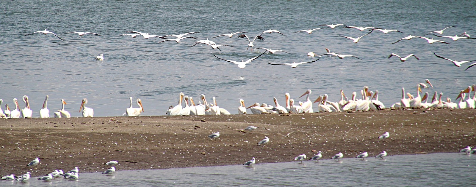
Not too far past the bridge is a Phillips 66 gas station sign and one for Riverlands Audubon Center. A chance to see birds and I’m in! I pass the gas station and pull into a parking area on the right where I get a couple of photos of birds in flight across an expanse of water. They’re really too far away. But it’s getting close to 2 p.m. and I don’t want to spend a lot of time here. Instead of going on the center, I park on the main road near another photographer. This guy has two tripods set up and both cameras have large telephoto lenses.
 |
| Flight and reflections |
We chat for 20 minutes as he’s eager to point out a couple of rare birds in the flocks of herons and pelicans. I can’t see the ones he’s pointing out, though. My lens doesn’t give that close a view. However, I get some nice pictures of my own and we have a great conversation about birds and travel. I love how nice people are and I’m amazed when they have a connection to New Hampshire.
 |
| Bellefontaine Bridge and the Lewis Bridge, W.Alton, Mo. |
He tells me not to take I-270 to I-70, but to take the I-370 off of I-270 which swings farther out around St. Louis and is not so heavy with traffic. He gives points of reference which I appreciate. I’m on the highway at 2 p.m. and cross the Lewis Bridge over the Missouri River.
Lewis Bridge
There’s not much information on this bridge except that it is a deck girder bridge carrying four lanes which opened in 1979. It runs parallel to the Bellefontaine Bridge, a four-span railroad bridge opened in 1893.
I take the guy’s advice and find I-370 is a much quieter route. It doesn’t take too long to get on I-70W and when I see a sign for a Comfort Inn at Exit 219 in O’Fallon, Mo., I stop for the night.
It’s 91 degrees. I’m checked in just before 3 p.m. and after settling in, swim in the indoor pool. Later I order pizza for supper. It was Chicago-style, very thinned crust and it had onions. I hate onions! Ewwww. Well, that was money wasted.
No comments:
Post a Comment